WHERE WILL IRMA TRACK?
Published 9:00 am Tuesday, September 5, 2017
All eyes are on Hurricane Irma as the major hurricane churns across the northern Caribbean and toward the U.S. Mainland.
Forecasters are encouraging residents who live along the Gulf and East coasts to be alert and pay attention to reports about the storm system, as well as prepare now.
As of 8 a.m., Tuesday, Irma was a Category 5 hurricane with maximum sustained winds of 130 mph.
AccuWeather forecasters say Irma will blast the Caribbean with flooding rain, damaging winds and rough surf this week, bringing life-threatening conditions to the islands.
A similar scenario could play out somewhere along the Gulf or East coasts this weekend or next week, depending on where the powerful storm tracks.
“This hurricane has the potential to be a major event for the East Coast,” Evan Meyers, expert senior meteorologist and chief operating officer, said. “It also have the potential to significantly strain FEMA and other governmental resources occurring so quickly on the heels of Harvey.”
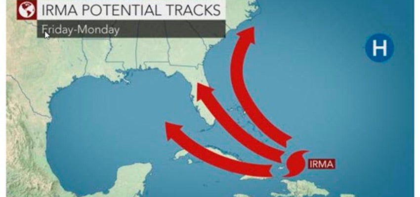
A landfall in Florida, Georgia or the Carolinas is all in the realm of possibilities.
Irma could also head into the Gulf of Mexico.
Still, another scenario is that Irma could curve northward and miss the East Coast entirely.
The exact path of Irma beyond the end of the week remains uncertain and will depend on a variety of moving parts in the atmosphere.
Alabama Meteorologist Rich Thomas weighed in Monday morning, as well.
“I’m afraid that the Irma news has gotten a little more serious,” he said. “The storm is growing stronger and the future steering mechanism which would hopefully steer Irma away from the U.S. may not cooperate. Thus the treat to the Bahamas and the United State has increased. The NHC has adjusted their cone to the left, and all of the global models are now adjusted left.”
“A large area of high pressure across the central North Atlantic is helping to steer Irma,” said AccuWeather Hurricane Expert Dan Kottlowski.
Kottlowski said this will be the main driving force of Irma over the next few days.
With the amount of uncertainty, residents are urged to prepare now rather than later.
If Irma were to make landfall as a Category 4 or 5 storm somewhere in the U.S., it would be historical.
“The U.S. has not sustained a direct hit from two Category 4 or above hurricanes in more than 100 years,” Myers said.
Thomas said that models tend to shift all the time.
“Although today’s news for the U.S. is not good, we are still just under a week away, and the tracks will continue to shift,” he said.
“I would say this: Nobody in the southeastern U.S. or the eastern U.S. should relax. Not even those of us on the Gulf Coast. All of us should watch the future track of Irma carefully. Be careful, as you view these spaghetti tracks. These are not carved in stone.”
More News


-
Polls
 Loading ...
-
-