Covington County EMA warns of severe weather
Published 2:50 pm Tuesday, March 30, 2021
|
Getting your Trinity Audio player ready...
|
The Covington County Emergency Management Agency is warning of possible severe weather event on Wednesday.
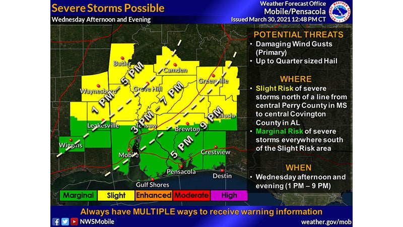
Confidence is increasing regarding a severe weather potential for Wednesday afternoon and evening, approximately 1 to 9 p.m., across the forecast area, especially across interior southeast Mississippi and interior southwest into south-central Alabama. A cold front is expected to move through the area and produce numerous showers and thunderstorms, some which may be severe. There also appears to be a threat for strong winds behind the cold front which will result in hazardous boating conditions and may pose a hazard to any outdoor COVID 19 testing sites. Finally, late this week it appears another round of cold overnight temperatures will lead to potential frost and freeze conditions, especially across interior portions of the region as well as normally sheltered cold spots closer to the coast.
There is a Slight Risk for Severe Thunderstorms across interior southeast Mississippi, and interior southwest and south-central Alabama. A few severe thunderstorms will be capable of producing wind gusts in excess of 60 mph along with the potential for hail up to the size of quarters. The tornado potential appears very low at this time. There remains a Marginal Risk for Severe Thunderstorms across the remainder of the forecast area to include the remainder of southeast Mississippi, coastal southwest Alabama, and the western Florida Panhandle.
A Wind Advisory is now in effect for coastal southwest Alabama and coastal sections of the western Florida Panhandle. Sustained north winds between 15 and 25 mph, with gusts up to 40 mph expected. Elsewhere north winds may become gusty across interior areas with gusts up to 30 mph possible. The wind advisory may need to be expanded further north if confidence increases regarding higher wind gusts.
The Wind Advisory is expected to be in place beginning Wednesday night, March 31, 10 p.m., through Thursday, April 1, at 7 a.m. Stronger wind gusts may continue into the day Thursday and the wind advisory may need to be extended and expanded.
Low temperatures are expected Thursday night, April 1, into early Friday morning, April 2, will likely fall into the lower to middle 30s across areas along and north of Interstate 10. These temperatures will likely result in widespread frost across the interior sections of southeast Mississippi, and interior southwest into south-central Alabama. A few areas may drop to at or below freezing, but confidence remains too low this far out to consider areas for frost advisories and/or freeze warnings. This will be monitored closely over the next few days with updates provided once confidence increases.
More News


-
Polls
 Loading ...
-
-