CC EMA: Severe weather possible across the area
Published 10:31 am Friday, April 9, 2021
|
Getting your Trinity Audio player ready...
|
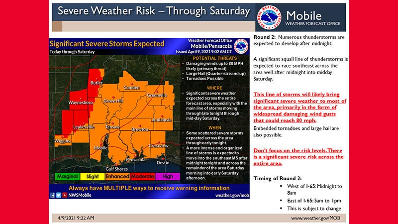
An active weather pattern is expected today through Saturday morning, according to the Covington County Emergency Management Agency. There will be two primary rounds of severe storms.
Today – Round 1: Scattered to locally numerous thunderstorms are expected across the region today. This event is ongoing at daybreak this morning and will likely continue into the early afternoon hours. Damaging winds and large hail will be the main threats, but cannot rule out a brief tornado. There may be a brief decrease in the coverage of storms late this afternoon as cloud debris from earlier storms may limit instability somewhat.
Tonight and Saturday – Round 2: A second round late tonight into Saturday morning has the potential to be a more significant severe weather producer as a more intense, organized squall line moves southeast across the region. For today and especially for tonight. “We are becoming more confident in the potential of a large organized squall line racing southeast across our area after midnight into Saturday morning. This squall line has the potential to bring widespread wind damage with damaging wind gusts potentially reaching up to 80 mph in some locations. Please note that the Moderate and Enhanced risks are primarily due to the significant wind damage potential. This squall line could also produce embedded tornadoes and large hail greater than quarter size,” stated a CC EMA press release.
In addition, a threat of Heavy Rainfall will also accompany these storms, which could lead to some Flash Flooding concerns today through Saturday. Rainfall totals of 2 to 4 inches, locally double totals, could be possible from now through Saturday.
The timing of Round 2 is expected to be approximately 5 a.m. to 1 p.m. for areas east of I-65.
More News


-
Polls
 Loading ...
-
-