County EMA monitoring possible severe weather today
Published 8:23 am Tuesday, April 5, 2022
|
Getting your Trinity Audio player ready...
|
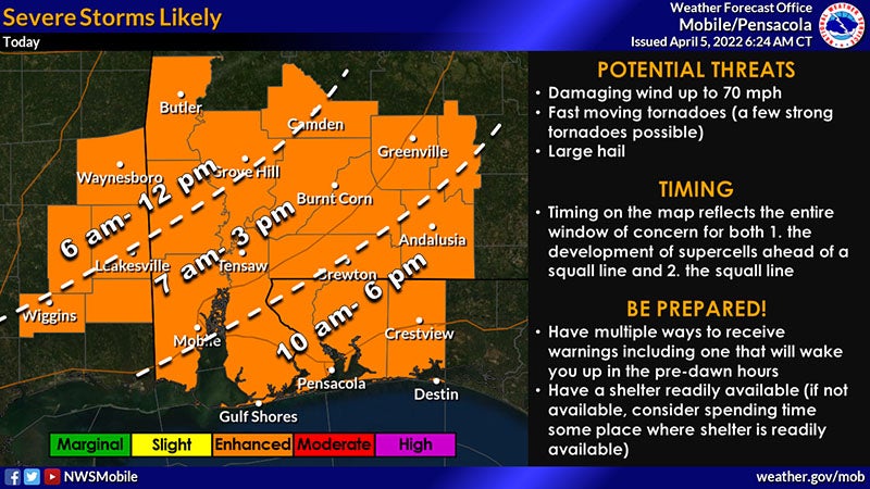
The Covington County Emergency Management Agency is expecting two rounds of severe weather on Tuesday.
A tornado watch is currently in effect for the entire area until 2 p.m. Additional watches will be possible later today.
The first round of severe storms will be the ongoing supercells ahead of the squall line as a warm front continues to move northward. Damaging winds, fast-moving tornadoes (a few strong tornadoes possible), and large hail are all possible with these supercells.
The second round of severe storms will be associated with the squall line. Damaging winds up to 70mph and fast-moving tornadoes are possible with the squall line. Flash flooding is possible (especially across urban areas, flood-prone areas, and our typical low-lying spots) as these storms will be capable of producing 1-3 inches of rain in a short period of time.
The ongoing supercell development across southeast Mississippi and parts of southwest and south-central Alabama will continue throughout the morning into the early afternoon hours ahead of the squall line. The supercell development is expected to expand further southeast to include the western Florida Panhandle by late this morning. Based on the latest guidance, the squall line should enter the southeast Mississippi counties around 9 a.m. and be nearing the I-65 corridor by 1 p.m. The line will likely be exiting the northwest Florida counties around 6 p.m. Flooding will remain a concern throughout the day, but especially as the squall line slides across the area.
Officials do expect another round of strong to severe storms on Wednesday afternoon through the evening hours. At this time, the Wednesday event does not appear to as potent as today’s severe weather, but damaging winds, large hail and a brief tornado are all possible.
More News


-
Polls
 Loading ...
-
-