WINTER WEATHER HERE, TOO?
Published 1:47 am Tuesday, February 24, 2015

What’s the weather going to do?
That seems to be a major question among weather forecasters throughout the state.
The National Weather Service is predicting rain to be widespread beginning Wednesday, but at least one weather model shows snow in South Alabama.
Rainfall totals of one to three inches are expected, with minor flooding in urban and low lying areas becoming possible.
Forecasters warn that ponding on roadways will increase the chances of hydroplaning.
Today a 50 percent chance of rain is expected mainly before noon, with a 30 percent chance coming Tuesday night.
High is expected to be near 53 and the low near 40.
Wednesday is expected to bring a 90 percent chance of rain, while it decreasing to a 40 percent chance Wednesday night. High will be around 47, with a low of 36.
The sun will peek through the clouds on Thursday and Friday, with lows in the mid to low 30s and highs in the low 50s.
Forecasters say the storm systems are making it complicated to forecast the coming days across Alabama.
An additional upper level through is expected to hit Alabama and the Gulf Coast states into today, setting up Wednesday’s rain.
Forecasters say they believe cold rain will be the main factor, but that temperatures are going to play a vital role in whether a wintry mix comes into play or not.
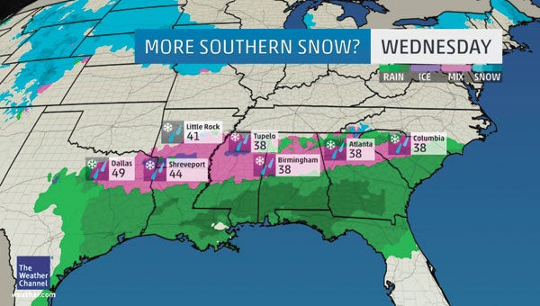
Wednesday’s system could definitely bring snow to North Alabama, but just how far south the snow/wintry mix could come has yet to be determined.
More News Main


SportsPlus
Week 9 College Football Computer Picks & Predictions
There are 57 Football Bowl Subdivision matchups on the Week 9 card, with Miami (FL) (+1.5) among the…
SWAC Football Power Rankings for Week 9
As we enter Week 9 of the college football schedule, which team is on top of the SWAC?…
Sun Belt Football Power Rankings for Week 9
Week 9 of the college football schedule is upon us. To see how every Sun Belt team compares…
How to Watch the MLB Baseball Playoffs on Sunday, Oct. 20: TV Channel, Live Streaming, Start Times
The New York Mets and the Los Angeles Dodgers take the field for one of many compelling matchups…
MLB Playoff Betting Lines and Picks Today | Oct. 20
The New York Mets and the Los Angeles Dodgers square off in one of many exciting matchups on…
-
Polls
 Loading ...
-
-