NWS releases updated Gulf storm information
Published 4:01 pm Monday, June 19, 2017
There is still some uncertainty about a weather system in the Gulf of Mexico.
According to the National Weather Service in Mobile’s 1:30 p.m., special tropical briefing, there is still a 90 percent chance that a tropical – or subtropical – cyclone will develop across the central Gulf of Mexico by mid-week.
Forecasters say the potential local impacts through mid-week include:
- Heavy rainfall and flooding, especially near the coast;
- High surf, deadly rip currents and minor coast flooding; and
- Gale force winds over Alabama/Northwest Florida Gulf Water;

Forecasters say there is still uncertainty on eventual track and strength of the system, the center of the system will likely stay west of the area and move into Texas or Louisiana.
However, forecasters say the track of the center is not as important with all of the heavy weather on the eastern side of the system.
Forecasters have increasing confidence on these threats regardless of the storm’s development:
- Heavy rain/flooding (Tuesday through at least Thursday);
- High risk of rip currents (Tuesday through the end of the week);
- Minor coastal flooding (Wednesday through at least Thursday); and
- High seas and potential gale force winds over the coastal waters (Tuesday through at least Thursday)
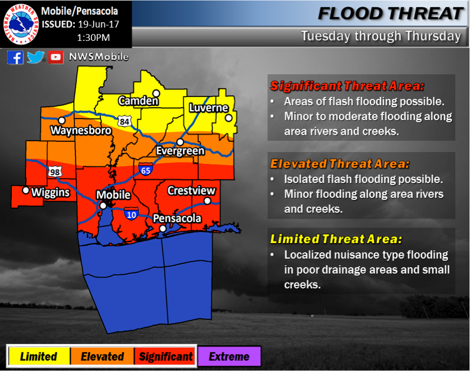
Locally, the rainfall and flooding potential is divided.
The southern portion of Covington County is in the significant threat area with areas of flash flooding possible and minor to moderate flooding along area rivers and creeks.
The rest of the county is in the elevated threat area with isolated flash flooding possible and minor flooding along rivers and creeks.
The threat could expand farther inland, specifically Wednesday into Thursday.
Additionally, rainfall forecast through Thursday calls for:
- Coastal: 4-8 inches over southern half of the area with locally higher totals over 10 inches possible;
- Well inland: 2 to 4 inches with locally higher totals possible.
Forecasters say that the region has seen 200 percent to 400 percent of normal rainfall, and that ground conditions are saturated.
The Star-News will update as more information becomes available.
More News


SportsPlus
Braves vs. Mets: Betting Preview for July 27
Francisco Lindor will lead the way for the New York Mets (55-48) on Saturday, July 27, when they…
How to Watch MLB Baseball on Saturday, July 27: TV Channel, Live Streaming, Start Times
The Cleveland Guardians and the Philadelphia Phillies square off for one of many compelling matchups on the MLB…
How to Watch the Braves vs. Mets Game: Streaming & TV Channel Info for July 27
The New York Mets will look to Francisco Lindor for continued offensive production when they hit the field…
How to Watch MLB Baseball on Friday, July 26: TV Channel, Live Streaming, Start Times
Today’s MLB slate has plenty of exciting matchups on the docket. Among those games is the Cleveland Guardians…
How to Watch the Braves vs. Mets Game: Streaming & TV Channel Info for July 26
Pete Alonso and the New York Mets will play Marcell Ozuna and the Atlanta Braves on Friday at…
-
Polls
 Loading ...
-
-