Tropics get active; 2 storms to watch
Published 12:56 am Saturday, August 5, 2017
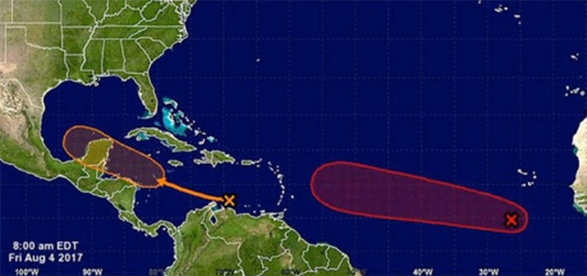
Hurricane forecasters are keeping an eye on two systems in the Atlantic, both of which have the potential to become Tropical Storm Franklin.
One, far out in the Atlantic, has the highest odds of becoming a named storm.
The second one could make it into the Gulf as early as next week.
That second wave, which forecasters are calling Invest 90L, was located over the eastern Caribbean Friday morning, the National Hurricane Center said.
Friday it was a strong tropical wave, but forecasters expect it to become more organized by the weekend when it makes its way into the Western Caribbean.
The first system’s formation chance is medium at 50 percent within the next 48 hours and high within the next five days at 80 percent.
It is described as a broad, low pressure system, associated with a tropical wave, and is producing a large area of disorganized showers and thunderstorms several hundred miles south and southwest of the Cabo Verde Islands.
Forecasters say environmental conditions are conducive for this system to consolidate and develop during the next five days, and a tropical depression is likely to form by early next week while loving west-northwestward at about 15 mph across the tropical Atlantic Ocean.
The second, the one in the Caribbean, is expected to move west-northwestward at about 15 mph across the western Caribbean Sea and Bay of Campeche through the middle of next week, where environmental conditions appear conducive for development. Formation chance in the next 48 hours is low at 20 percent. It ups to medium at 60 percent within the next five days.
More News


SportsPlus
Where to Watch Alabama State vs. North Carolina Central on TV or Streaming Live – September 1
On Sunday at 3:00 p.m. ET, the North Carolina Central Eagles will host the Alabama State Hornets. We…
How to Watch the Braves vs. Phillies Game: Streaming & TV Channel Info for August 31
Zack Wheeler and Max Fried will start for their respective teams when the Philadelphia Phillies and the Atlanta…
Braves vs. Phillies: Betting Preview for August 31
Atlanta Braves (74-61) will take on the Philadelphia Phillies (79-56) at Citizens Bank Park on Saturday, August 31…
How to Watch MLB Baseball on Saturday, August 31: TV Channel, Live Streaming, Start Times
The Los Angeles Dodgers versus the Arizona Diamondbacks is one of many solid options on today’s MLB slate.…
How to Watch the WNBA Today | August 31
The Connecticut Sun and Washington Mystics meet in the lone matchup on the WNBA schedule today. The WNBA…
-
Polls
 Loading ...
-
-