Morning update: Increased confidence of PCB-area landfall
Published 12:27 am Wednesday, October 10, 2018
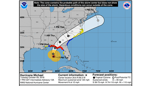
Confidence continues to increase that Hurricane Michael will make landfill in the vicinity of Panama City, but small deviations due to wobbles close to the coast could move the track a little further west, forecasters in the National Weather Service in Mobile said in their early morning update today.
Michael is a Category 4 storm, and could come ashore with 145 m.p.h. winds. It is the largest storm to hit the Florida Panhandle in recorded history, and is strengthening, with a slight potential to briefly become a Category 5 hurricane.
Tropical storm conditions are expected later today over portions of south central and southeast Alabama. An occasional gust to hurricane force is possible if the hurricane wobbles westward closer to Destin.
Forecasts call for 1 to 3 inches of rain, with greater chances of weather impacts in the Florala and Wing area
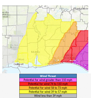
At the 5 p.m. briefing, the NWS said the probability of tropical storm force winds remains high east of I-65, especially over northwest Florida and south central Alabama.
The most extensive wind threat was across southeast Covington County, with the potential for winds from 74 to 110 miles per hour. In the western part of the county, winds were expected to reach 58 to 73 miles per hour.
Covington County should see 2 to 3 inches of rain, and a flash flood watch also was issued for Covington County.
Tropical storm conditions will begin impacting the coast by early Wednesday morning, the NWS said.
More News


-
Polls
 Loading ...
-
-