Severe weather possible
Published 10:37 pm Friday, November 30, 2018
There is a chance Covington County could see thunderstorms and flash flooding Saturday, Covington County Emergency Management Agency director Susan Harris said.
“Numerous to widespread showers and thunderstorms will develop as a strong upper level disturbance over the western Gulf of Mexico lifts northeast across the region,” Harris said. “A few storms may become strong to severe over the entire forecast area, along with heavy rainfall and possible localized flooding.”
Harris said that forecasters expected storms to move in after midnight on Friday and continue until Saturday afternoon.
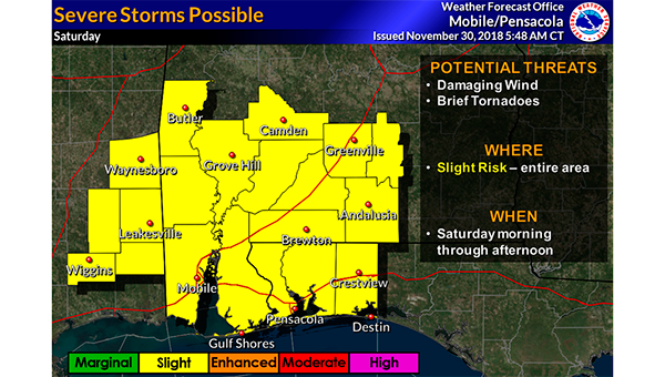
“A marginal severe threat is expected late tonight west of a line from Waynesboro Mississippi to Navarre Beach Florida,” Harris said Friday. “With the exception of a slight severe threat across southern Stone County in Mississippi. The slight severe threat will then shift eastward across the entire forecast area Saturday morning through early Saturday afternoon, with the threat diminishing thereafter.”
Harris said that the primary threats will be strong to severe locally, with damaging wind gusts in the 40 to 60 mile per hour range and perhaps a brief tornado.
“ Heavy rainfall and localized flooding will be possible mainly east of I-65 where rainfall totals between 2 and 4 inches is likely,” Harris said. “With locally higher amounts possible, resulting in some nuisance flooding.”
More News


SportsPlus
How to Watch MLB Baseball on Friday, July 26: TV Channel, Live Streaming, Start Times
Today’s MLB slate has plenty of exciting matchups on the docket. Among those games is the Cleveland Guardians…
How to Watch the Braves vs. Mets Game: Streaming & TV Channel Info for July 26
Pete Alonso and the New York Mets will play Marcell Ozuna and the Atlanta Braves on Friday at…
Braves vs. Mets: Betting Preview for July 26
Francisco Lindor and the New York Mets (54-48) will host Marcell Ozuna and the Atlanta Braves (54-47) at…
Atlanta Falcons vs. Denver Broncos Week 11 Tickets Available – Sunday, November 17 at Empower Field at Mile High
On Sunday, November 17, 2024, the Atlanta Falcons (0-0) go head to head with the Denver Broncos (0-0)…
Atlanta Falcons vs. Seattle Seahawks Week 7 Tickets Available – Sunday, October 20 at Mercedes-Benz Stadium
On Sunday, October 20, 2024, the Seattle Seahawks (0-0) play the Atlanta Falcons (0-0) at Mercedes-Benz Stadium. Hoping…
-
Polls
 Loading ...
-
-