Flash flooding possible tonight
Published 12:45 am Thursday, December 13, 2018
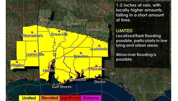
According to the Covington County Emergency Management Agency director Susan Harris, there is a marginal risk of severe weather, heavy rainfall and a flood threat this evening.
“We continue to monitor a system which will move across our area later this week,” Harris said. “This will be an event similar to the last few that we’ve had, a low-end risk of severe storms along with the potential for heavy rainfall/flooding. The timing will be from late Thursday afternoon through Thursday night.”
Harris said that forecasters predict one to two inches of rain.
“We are expecting one to two inches of rain with locally higher amounts to fall in a short amount of time as a line of heavy rain and storms shifts eastward across the area,” Harris said. “A limited threat of flooding continues for much of our area. However, please note that areas that received heavy rains on Saturday, Dec. 8, could see an increased elevated threat in later updates. Currently there is ongoing or forecast minor flooding along some portions of the Alabama and Tombigbee rivers. However, this additional rainfall could result in minor flooding along creeks and rivers generally in the western Florida panhandle.”
Harris said that the heaviest rainfall is expected Thursday afternoon.
“The heaviest rainfall is expected to begin Thursday afternoon over southeast Mississippi,” Harris said. “Then spread further east during Thursday night.”
Harris said that an isolated severe storm or two will be capable of producing localized damaging winds and possibly an isolated tornado in the marginal risk area.
“The severe weather will begin first over southeast Mississippi late Thursday afternoon,” Harris said. “Then over the remainder of the marginal risk area through Thursday night.”
More News


SportsPlus
How to Watch MLB Baseball on Friday, July 26: TV Channel, Live Streaming, Start Times
Today’s MLB slate has plenty of exciting matchups on the docket. Among those games is the Cleveland Guardians…
How to Watch the Braves vs. Mets Game: Streaming & TV Channel Info for July 26
Pete Alonso and the New York Mets will play Marcell Ozuna and the Atlanta Braves on Friday at…
Braves vs. Mets: Betting Preview for July 26
Francisco Lindor and the New York Mets (54-48) will host Marcell Ozuna and the Atlanta Braves (54-47) at…
Atlanta Falcons vs. Denver Broncos Week 11 Tickets Available – Sunday, November 17 at Empower Field at Mile High
On Sunday, November 17, 2024, the Atlanta Falcons (0-0) go head to head with the Denver Broncos (0-0)…
Atlanta Falcons vs. Seattle Seahawks Week 7 Tickets Available – Sunday, October 20 at Mercedes-Benz Stadium
On Sunday, October 20, 2024, the Seattle Seahawks (0-0) play the Atlanta Falcons (0-0) at Mercedes-Benz Stadium. Hoping…
-
Polls
 Loading ...
-
-