Covington EMA: Severe weather event possible
Published 4:42 pm Tuesday, March 16, 2021
- Wednesday into Wednesday night
|
Getting your Trinity Audio player ready...
|
According to the Covington County Emergency Management Agency, there is potential for a significant severe weather event to begin early hours of Wednesday and continuing through the day.
As a precaution, Governor Kay Ivey on Tuesday declared a state of emergency for all Alabama counties to “ensure we are ready to act in any way needed from the state level.”
Likely to definite storms will occur today along and north of a line from Wiggins MS to Andalusia AL, with a chance of storms south of this line. A higher coverage of storms is forecast for Wednesday and Wednesday night.
Beginning Tuesday through mid evening there is a Marginal Risk of severe storms for an area roughly north of a line from Leakesville, Mississippi to Florala, Alabama. The primary threats with any severe storms that develop will be damaging wind gusts and/or large hail, with a brief tornado possible. Locally heavy rainfall may also occur.
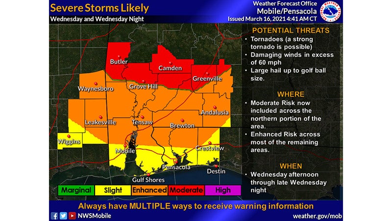
Wednesday into Wednesday night will be the period when significant severe weather is expected. Long track tornadoes are possible, along with damaging wind gusts, large hail, and locally heavy rainfall. A Moderate Risk of severe storms now exists across our northern zones, while an Enhanced Risk of severe storms exists for nearly the entire remaining area.
• WHAT?
All modes of severe weather possible to include damaging wind gusts, severe hail and possible strong (EF2 or higher) tornadoes.
• WHERE and WHEN?
Round 1 -The first round of isolated to scattered intense to severe thunderstorms develops into early afternoon Wednesday. This is when to expect isolated discrete cells region-wide, thus it will be hard to pinpoint an exact location for any one town or location. These will move from southwest to northeast across the area during the rest of the day.
Round 2 – A better threat for severe thunderstorms will likely evolve from west to east from early afternoon and into the overnight hours. The scenario favors a severe thunderstorm squall line following up, possibly overtaking discrete cells ahead of it as it moves further east. The severe threat will end with the passage of a cold front prior to sunrise Thursday morning.
Potential Time Ranges for the Round 2 Squall Line:
7 PM-1 AM – Interior SE MS east to the I-65 Corridor.
1 AM-5 AM – I-65 Corridor to east of a Greenville, AL to Destin, FL line.
More News Main


SportsPlus
Braves vs. Mets: Betting Preview for July 27
Francisco Lindor will lead the way for the New York Mets (55-48) on Saturday, July 27, when they…
How to Watch MLB Baseball on Saturday, July 27: TV Channel, Live Streaming, Start Times
The Cleveland Guardians and the Philadelphia Phillies square off for one of many compelling matchups on the MLB…
How to Watch the Braves vs. Mets Game: Streaming & TV Channel Info for July 27
The New York Mets will look to Francisco Lindor for continued offensive production when they hit the field…
How to Watch MLB Baseball on Friday, July 26: TV Channel, Live Streaming, Start Times
Today’s MLB slate has plenty of exciting matchups on the docket. Among those games is the Cleveland Guardians…
How to Watch the Braves vs. Mets Game: Streaming & TV Channel Info for July 26
Pete Alonso and the New York Mets will play Marcell Ozuna and the Atlanta Braves on Friday at…
-
Polls
 Loading ...
-
-