‘Enhanced Risk’ of severe weather across the area
Published 4:50 pm Wednesday, March 17, 2021
|
Getting your Trinity Audio player ready...
|
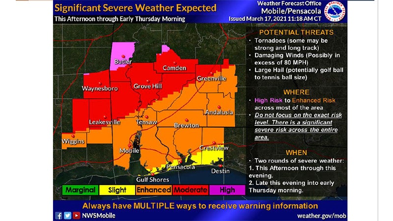
There is an “Enhanced Risk” of severe weather for Covington County tonight.
According to the National Weather Service and the Covington County Emergency Management Agency, isolated supercells are expected to develop along and west of I-65 beginning midday Wednesday and continuing through the early evening hours. These storms will have potential to quickly turn severe and become tornadic.
A more organized line of storms will develop ahead of a cold front and move west to east across the area late this evening and into the overnight hours. This line could be in the form of a broken line of supercells that will carry substantial tornado and severe weather threats.
“A strong tornado is possible with this activity, particularly in the Moderate to Enhanced Risk zones,” according to the NWS.
For the area of South Central/South West Alabama and the Florida Panhandle, the line of the storm will likely be about 2 to 6 a.m.
The NWS said there could be lulls in storm activity, especially in advance of the main line of the storms.
The main threats from the storm include tornadoes, damaging straight-line winds, and large hail.
More News


SportsPlus
How to Watch MLB Baseball on Friday, July 26: TV Channel, Live Streaming, Start Times
Today’s MLB slate has plenty of exciting matchups on the docket. Among those games is the Cleveland Guardians…
How to Watch the Braves vs. Mets Game: Streaming & TV Channel Info for July 26
Pete Alonso and the New York Mets will play Marcell Ozuna and the Atlanta Braves on Friday at…
Braves vs. Mets: Betting Preview for July 26
Francisco Lindor and the New York Mets (54-48) will host Marcell Ozuna and the Atlanta Braves (54-47) at…
Atlanta Falcons vs. Denver Broncos Week 11 Tickets Available – Sunday, November 17 at Empower Field at Mile High
On Sunday, November 17, 2024, the Atlanta Falcons (0-0) go head to head with the Denver Broncos (0-0)…
Atlanta Falcons vs. Seattle Seahawks Week 7 Tickets Available – Sunday, October 20 at Mercedes-Benz Stadium
On Sunday, October 20, 2024, the Seattle Seahawks (0-0) play the Atlanta Falcons (0-0) at Mercedes-Benz Stadium. Hoping…
-
Polls
 Loading ...
-
-