Strong storm system could arrive Thursday
Published 4:00 pm Tuesday, February 28, 2023
|
Getting your Trinity Audio player ready...
|
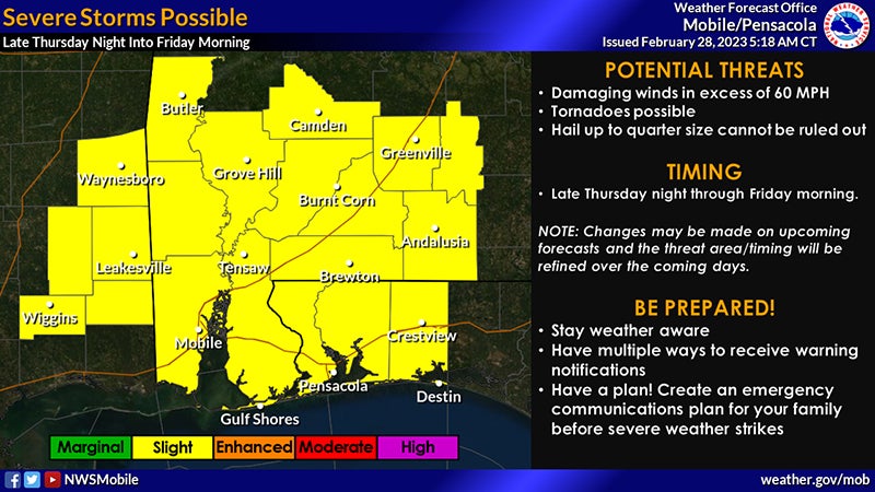
The Covington County Emergency Management Agency is tracking a storm system expected to make its way through the area early Thursday morning.
According to officials, this potent storm system is expected to lift from the southern Plains to the Mississippi Valley Thursday night into Friday morning. A round of severe storms may impact this forecast area ahead of the associated approaching cold front during this time.
The Covington County area is currently in an area deemed at “slight risk” of severe storms, with the top concerns being damaging winds in excess of 60 miles per hour and a few tornadoes. Instances of quarter-sized hail are all possible.
The round of storms is still expected to enter southeast Mississippi and interior southwest Alabama during the overnight hours, perhaps around 4 a.m. on Thursday night. The front should move east across the rest of southwest and south central Alabama and the western Florida panhandle through the morning hours on Friday. The latest indications are that the severe threat should exit to the east by around noon on Friday. The threat areas and timing could change.
“The main takeaway is that atmospheric ingredients favor the potential for damaging winds and a few tornadoes over our entire area late Thursday night into Friday morning,” officials said.
Breezy southerly gradient winds will likely develop ahead of the front late Thursday night into early Friday morning. Some gusts up to around 40 miles per hour are possible.
More News


SportsPlus
NFL Week 8 Picks Against the Spread, Tips and Predictions
According to our projections, the best bet against the spread in the NFL among Week 8’s 16 matchups…
NFL Week 8 Computer Predictions, Best Bets, Over/Under Picks
Looking at the Week 8 NFL slate, we have the Broncos (-8.5) as the best bet on the…
How to Watch the NBA Today, October 23
Today’s NBA slate features 10 games, including the Indiana Pacers versus the Detroit Pistons. We’ve got everything you…
NBA Spread and Total Picks for Today, October 23
The NBA lineup today is not one to miss. The contests include the Orlando Magic taking on the…
How to Watch the Hawks vs. Nets Game: Streaming & TV Channel Info for October 23
In the first game of the 2024-25 season for both teams, the Atlanta Hawks go up against the…
-
Polls
 Loading ...
-
-