Tropics heating up: Forecasters watching 3 systems
Published 11:11 pm Wednesday, August 16, 2017
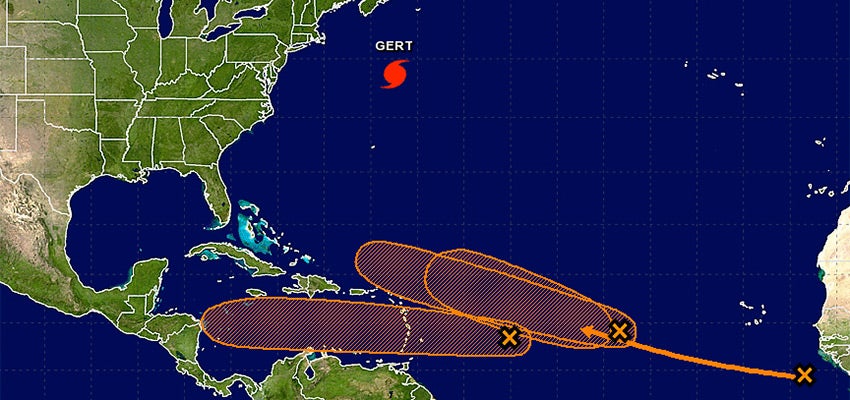
The National Hurricane Center is keeping an eye on three systems in the Atlantic Ocean, as well as Hurricane Gert.
Hurricane Gert poses no threat to the U.S. Mainland, and on Wednesday was located a few hundred miles north of Bermuda and was expected to move toward the U.K. by Monday.
The first system of low pressure being watched is located about 900 miles east of the Lesser Antilles and continues to produce disorganized showers and a few thunderstorms.
The system is moving westward at 15 to 20 mph, and it is expected to cross into the Caribbean Sea on Friday.
Upper-level winds are forecast to become a little more conducive for development during the next several days, and interests in the Lesser Antilles should monitor the progress of this system.
Forecasters say the formation chance through 48 hours is low at 30 percent. Formation chance of this system through the next five days is medium at 40 percent.
A second area of low pressure located several hundred miles west of the Cabo Verde Islands is also producing disorganized showers and thunderstorms.
Gradual development of this system is possible during the next few days before upper-level winds become less conducive over the weekend.
This system is expected to move west-northwestward at 15 to 20 mph during the next several days. Formation chance through 48 hours is low at 30 percent. Formation chance through the next five days is medium at 40 percent.
Finally, forecasters are looking at a tropical wave near the west coast of Africa that is producing a large amount of disorganized showers and thunderstorms.
Environmental conditions appear conducive for gradual development of this wave while it moves westward to west-northwestward at about 15 mph during the next several days. Formation chance through 48 hours is at 0 percent. Formation chance through five days is at 40 percent.
While it is too early to tell the paths of these storms, it’s never too early for locals to plan ahead.
It’s been 13 years since Hurricane Ivan and 12 since Hurricane Katrina hit the U.S. Mainland. Before that, there was Hurricane Opal in 1995.
With it being more than a decade since the local area was struck by a hurricane, it’s important for locals not to be complacent.
Hurricane Ivan brought 9.96 inches of rain in a 48-hour time period to Andalusia, according to the National Weather Service.
The National Weather Service also estimated wind gusts between 60 mph and 80 mph.
Hurricane Opal, is a reminder of how quickly a hurricane can intensify.
The NWS says that Opal was a Category 2 storm with 100 mph winds when residents when to sleep on Oct. 3, 1995, and by 10 a.m. the next day, the storm had intensified to a top-end Category 4 storm with winds of 150 mph.
That caused a last-minute evacuation, which jammed up traffic on many major highways including I-65, the weather service said.
Eventually Opal came ashore on Pensacola Beach as a Category 3 hurricane with maximum winds of 115 mph on Oct. 4, 1995.
It’s not too late to get your preparedness kit ready. Hurricane season runs through November.
EMA Director Susan Harris is always encouraging people to be ready.
“We want everyone to be prepared,” she said.
There are currently no shelters in the county for before or during the storm, so locals are encouraged to have a plan in place for when and if a storm strikes.
More News


-
Polls
 Loading ...
-
-