Not-so-little Debby
Published 12:04 am Tuesday, June 26, 2012

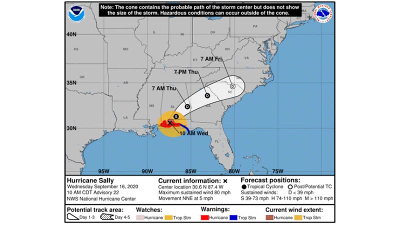
At last look, Covington County had a 10-20 percent chance of seeing Tropical Storm force winds from T.S. Debby. | Graphic courtesy of NOAA
EMA: Don’t turn back on storm
Weather officials are watching and waiting as a “not-so-little” Debby churns in the Gulf of Mexico.
As of Monday afternoon, officials with the National Weather Service reported that Tropical Storm Debby was sitting about 50 miles south-southwest of Apalachicola, Fla., moving at a rate of 5 mph.
With maximum sustained winds of 45 mph, tropical storm warnings were in effect from Destin, Fla., to Englewood, Fla. Described as a “large tropical cyclone,” the storm’s strongest winds and much of the heaviest rainfall are well removed from the center of circulation.
Still, it’s anyone’s guess where the brunt of the winds and rains will land, said County EMA Director Susan Harris.
“We shouldn’t turn our back on this storm,” Harris said. “It could make a turn to the west, and we’d be affected immediately. As it looks right now, we may have some issues with flooding, depending on where the storm lands. (NWS officials are) saying now it’s taking an easterly rotation, and we should see rain – which would be a good thing for us. We need the rain.”
On a local front Monday, Covington County was under a wind advisory because of Tropical Storm Debby, as gusts up to 35 mph whipped trees and caused dark storm clouds to roll across the sky.
“Remember – these storms can change tracks in an instant, and residents need to prepare and stay informed,” Harris said.
The NWS is reporting the threat exists for significant river flooding in South Central Alabama early this week from the heavy rainfall associated with T.S. Debby. Bands of rain will continue to move across the Panhandle as the storm moves slowly north. At this time, there is great deal of uncertainty as to the storm’s eventual track, but it appears that heavy rainfall could spread across Northwest Florida and South Central Alabama during the next 24 hours.
Locals will also have to watch out for high heat indicies as the week progresses. NWS reports the heat index will range from 100 to 105 on Friday, and 105 to 110 on Saturday and Sunday.
More Covington County

SportsPlus
NFL Week 8 Picks Against the Spread, Tips and Predictions
According to our projections, the best bet against the spread in the NFL among Week 8’s 16 matchups…
NFL Week 8 Computer Predictions, Best Bets, Over/Under Picks
Looking at the Week 8 NFL slate, we have the Broncos (-8.5) as the best bet on the…
How to Watch the NBA Today, October 23
Today’s NBA slate features 10 games, including the Indiana Pacers versus the Detroit Pistons. We’ve got everything you…
NBA Spread and Total Picks for Today, October 23
The NBA lineup today is not one to miss. The contests include the Orlando Magic taking on the…
How to Watch the Hawks vs. Nets Game: Streaming & TV Channel Info for October 23
In the first game of the 2024-25 season for both teams, the Atlanta Hawks go up against the…
-
Polls
 Loading ...
-
-