National Weather Service warns of multiple hazards as weather event moves into area
Published 9:00 am Wednesday, April 10, 2024
|
Getting your Trinity Audio player ready...
|
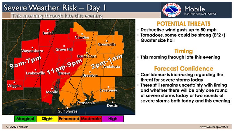
Multiple hazards are anticipated today through Thursday to include severe thunderstorms, flooding, non-thunderstorm winds, and coastal hazards, according to the Covington County Emergency Management Agency.
The Covington County area is forecasted for an “enhanced risk” of experiencing destructive wind gusts up to 80 miles per hour with the possibility of strong tornadoes, and quarter-sized hail.
The first day of the storms, Wednesday, is expected to see the worse weather events beginning at approximately 2 p.m. through 1 a.m.
“Confidence is increasing regarding the threat for severe storms today,” stated a National Weather Service announcement. “There still remains uncertainty with timing and whether there will be only one round of severe storms both today and this evening.”
Confidence in the severe weather events is higher in the “moderate risk” areas, which include Mobile County, northwest Baldwin, and areas to the north of those counties and west of Interstate 65.
“All modes of severe weather are possible with tornadoes and damaging winds the most significant threats. A strong tornado will also be possible,” according to the NWS.
The forecast is citing two possible scenarios:
- A squall-line moves across the area from west to east from mid-morning through late afternoon. In advance of the squall-line, a few discrete supercells will be possible across far southeast Mississippi and potentially as far east as coastal Alabama. Damaging winds up to 80 mph and tornadoes will be possible with any supercell and within the squall-line.
- The squall-line poses a threat for damaging winds and tornadoes across southeast Mississippi but weakens as it moves into Alabama and transitions to a flood threat north of the I-10 corridor. Across coastal Alabama and the Florida Panhandle, the severe weather threat would be this evening into the overnight hours with a tornado and damaging wind threat.
Flash and river flooding are also possible with up to 3-5 inches of rain, with some areas possibly receiving up to 6-8 inches.
Wind gusts between 40-50 miles per hour are possible with sustained winds of 20-30 miles per hour. The NWS has the highest confidence that the strongest winds will be along the coastal area and into the Florida Panhandle.
More News


SportsPlus
Braves vs. Mets: Betting Preview for July 27
Francisco Lindor will lead the way for the New York Mets (55-48) on Saturday, July 27, when they…
How to Watch MLB Baseball on Saturday, July 27: TV Channel, Live Streaming, Start Times
The Cleveland Guardians and the Philadelphia Phillies square off for one of many compelling matchups on the MLB…
How to Watch the Braves vs. Mets Game: Streaming & TV Channel Info for July 27
The New York Mets will look to Francisco Lindor for continued offensive production when they hit the field…
How to Watch MLB Baseball on Friday, July 26: TV Channel, Live Streaming, Start Times
Today’s MLB slate has plenty of exciting matchups on the docket. Among those games is the Cleveland Guardians…
How to Watch the Braves vs. Mets Game: Streaming & TV Channel Info for July 26
Pete Alonso and the New York Mets will play Marcell Ozuna and the Atlanta Braves on Friday at…
-
Polls
 Loading ...
-
-